 Weston Ski T... Blue Hills S... Nashoba Vall... Bradford Ski...
 Brundage Mountain Resort
  McCall Airport, ID Updated Apr 23 @ 11:09

 South
South WebCams
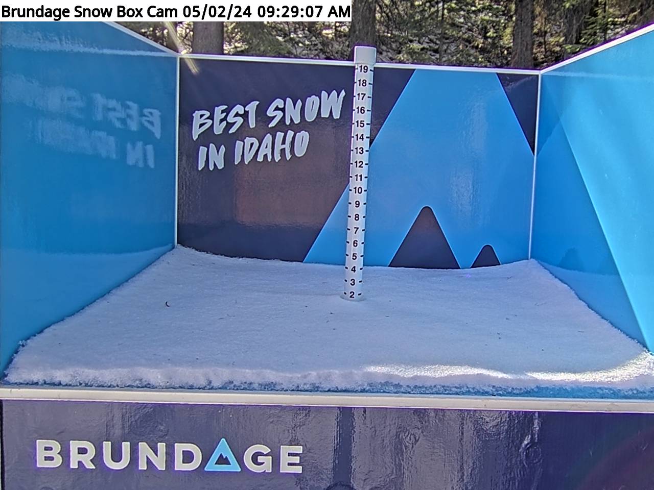
Base Elevation Snow Cam!

Bear Chair - 6,490'

Lakeview - 7,600'
TUESDAY
Apr 23
52° / 40°

4 - 11
mph
 0
0
WEDNESDAY
Apr 24

54° / 37°
5 - 12
mph
0
THURSDAY
Apr 25

47° / 37°
5 - 12
mph
0
FRIDAY
Apr 26

36° / 32°
5 - 13
mph
3
SATURDAY
Apr 27
39° / 31°
4 - 12
mph
1
SUNDAY
Apr 28
38° / 33°
4 - 12
mph
1
MONDAY
Apr 29
45° / 32°
7 - 15
mph
0
advertisement

Partly cloudy becoming mostly cloudy at times and then partly cloudy overnight. Expect windy conditions at times.
No snow.
No precipitation expected.
Hi: 52°Low: 40°
9,582 feet to 10318 feet
Winds SW at 6 to 14 mph in the morning, becoming variable at 4 to 11 mph in the afternoon, and then variable at 4 to 12 mph overnight.
Partly cloudy becoming mostly cloudy at times and then partly cloudy overnight. Expect windy conditions at times.
No snow.
No precipitation expected.
Hi: 44°Low: 41°
9,582 feet to 10318 feet
Winds SW at 8 to 16 mph in the morning, becoming variable at 4 to 12 mph in the afternoon, and then S at 8 to 16 mph overnight.
Mostly cloudy becoming partly cloudy at times continuing through overnight. Periods of rain are expected at any time.
No snow.
Potential Precip:
0.06 to 0.3
Hi: 54°Low: 37°
8,588 feet to 10245 feet
Winds SW at 8 to 16 mph in the morning, becoming variable at 5 to 12 mph in the afternoon, and then variable at 4 to 12 mph overnight.
Mostly cloudy becoming partly cloudy at times continuing through overnight. Periods of rain and snow are expected overnight.
Light snow overnight. Snowfall is forecast to be a trace amount overnight.
Potential Precip:
0.06 to 0.3
Hi: 46°Low: 35°
8,588 feet to 10245 feet
Winds SW at 11 to 20 mph in the morning, becoming variable at 4 to 12 mph in the afternoon, and then variable at 3 to 11 mph overnight.
Mostly cloudy becoming cloudy in the late morning continuing through overnight, with periods of rain and snow expected overnight.
Light snow in the evening through overnight. Snowfall is forecast to be a trace amount in the evening and overnight.
Potential Precip:
0.12 to 0.6
Hi: 47°Low: 37°
7,273 feet to 8968 feet
Winds W at 6 to 14 mph in the morning, becoming variable at 5 to 12 mph in the afternoon, and then variable at 3 to 11 mph overnight.
Mostly cloudy becoming cloudy in the late morning continuing through overnight, with periods of rain and snow expected overnight.
Light snow through the day and into overnight, with periods of moderate overnight. Snowfall is forecast to be a trace amount during the day, and 1 to 2 inches in the evening and overnight.
Potential Precip:
0.12 to 0.6
Hi: 39°Low: 31°
7,273 feet to 8968 feet
Winds W at 8 to 16 mph in the morning, becoming variable at 5 to 12 mph in the afternoon, and then variable at 4 to 12 mph overnight.
Cloudy through the day and overnight, with periods of snow expected at any time.
Periods of light to moderate snow throughout the day and overnight. Snowfall is forecast to be 3 to 5 inches.
Potential Precip:
0.23 to 1.17
Hi: 36°Low: 32°
5,963 feet to 6967 feet
Winds variable at 4 to 12 mph in the morning, becoming variable at 5 to 13 mph in the afternoon, and then variable at 4 to 12 mph overnight.
Cloudy through the day and overnight, with periods of snow expected at any time.
Periods of moderate to heavy snow throughout the day, moderate at times overnight. Snowfall is forecast to be 6 to 9 inches.
Potential Precip:
0.23 to 1.17
Hi: 29°Low: 27°
5,963 feet to 6967 feet
Winds NW at 9 to 17 mph in the morning, becoming N at 12 to 21 mph in the afternoon, and then variable at 10 to 18 mph overnight.
Mostly cloudy becoming partly cloudy in the late morning and then mostly cloudy overnight. Periods of snow are expected in the morning through overnight.
Periods of light snow throughout the day, moderate at times overnight. Snowfall is forecast to be 1 to 2 inches.
Potential Precip:
0.11 to 0.57
Hi: 39°Low: 31°
5,504 feet to 7484 feet
Winds variable at 4 to 12 mph through the day, becoming variable at 3 to 11 mph overnight.
Mostly cloudy becoming partly cloudy in the late morning and then mostly cloudy overnight. Periods of snow are expected in the morning through overnight.
Periods of light snow throughout the day, heavy at times overnight. Snowfall is forecast to be 3 to 5 inches.
Potential Precip:
0.11 to 0.57
Hi: 31°Low: 27°
5,504 feet to 7484 feet
Winds variable at 4 to 12 mph through the day, becoming S at 7 to 15 mph overnight.
Cloudy becoming mostly cloudy at times continuing through overnight, with periods of snow expected at any time.
Periods of light snow throughout the day and overnight. Snowfall is forecast to be 1 to 2 inches.
Potential Precip:
0.12 to 0.61
Hi: 38°Low: 34°
6,420 feet to 7381 feet
Winds variable at 4 to 12 mph through the day, becoming S at 6 to 14 mph overnight.
Cloudy becoming mostly cloudy at times continuing through overnight, with periods of snow expected at any time.
Periods of light to moderate snow throughout the day and overnight. Snowfall is forecast to be 3 to 5 inches.
Potential Precip:
0.12 to 0.61
Hi: 31°Low: 27°
6,420 feet to 7381 feet
Winds SW at 9 to 17 mph through the day, becoming SW at 12 to 21 mph overnight.
Mostly cloudy becoming partly cloudy in the late morning continuing through overnight, with periods of rain and snow expected overnight.
Periods of light snow throughout the day. Snowfall is forecast to be a trace amount.
Potential Precip:
0.05 to 0.27
Hi: 45°Low: 32°
6,409 feet to 8799 feet
Winds variable at 7 to 15 mph through the day, becoming variable at 4 to 12 mph overnight.
Mostly cloudy becoming partly cloudy in the late morning continuing through overnight, with periods of snow expected in the morning through overnight.
Periods of light to moderate snow throughout the day, light at times overnight. Snowfall is forecast to be 1 to 2 inches.
Potential Precip:
0.05 to 0.27
Hi: 37°Low: 29°
6,409 feet to 8799 feet
Winds SW at 12 to 21 mph through the day, becoming SE at 9 to 18 mph overnight.
 Sunrise & Sunset

Lunar Calendar


 Brundage Mountain Resort Discussion
  Snow Maps and Weather Stations in the Area
 ![]() 7in, past 3 days. Snow surface is packed powder and powder
7in, past 3 days. Snow surface is packed powder and powder
Snow report provided by SnoCountry
 Mountain Base


