 Mt Waterman Mountain Hig... Mt Baldy Alta Sierra...
 Jackson Hole Mountain Resort
  Jackson, Jackson Hole Airport, WY Updated Apr 07 @ 03:14

 Southwest
 WebCams
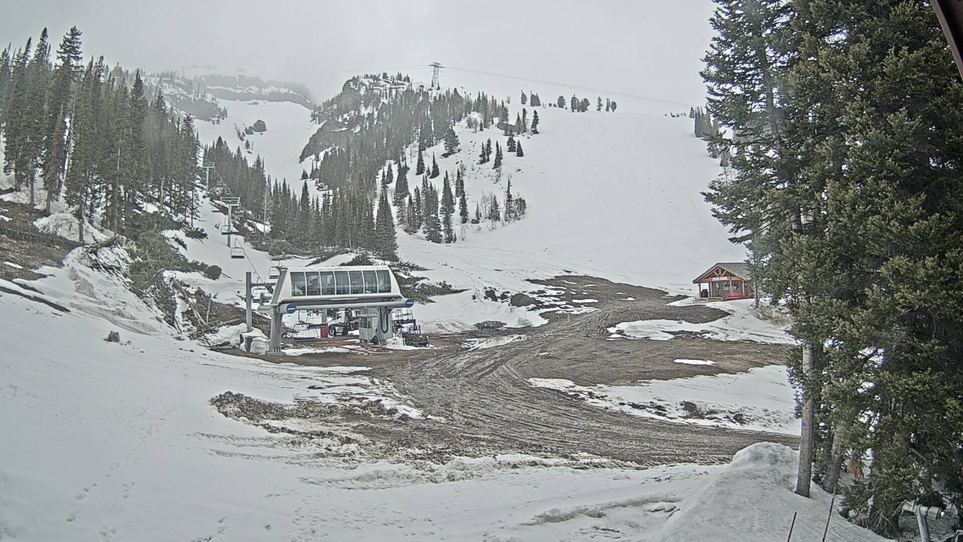
Thunder Chair - 9,300ft

Lower Faces - 6,311ft

Apres Vous

Rendezvous
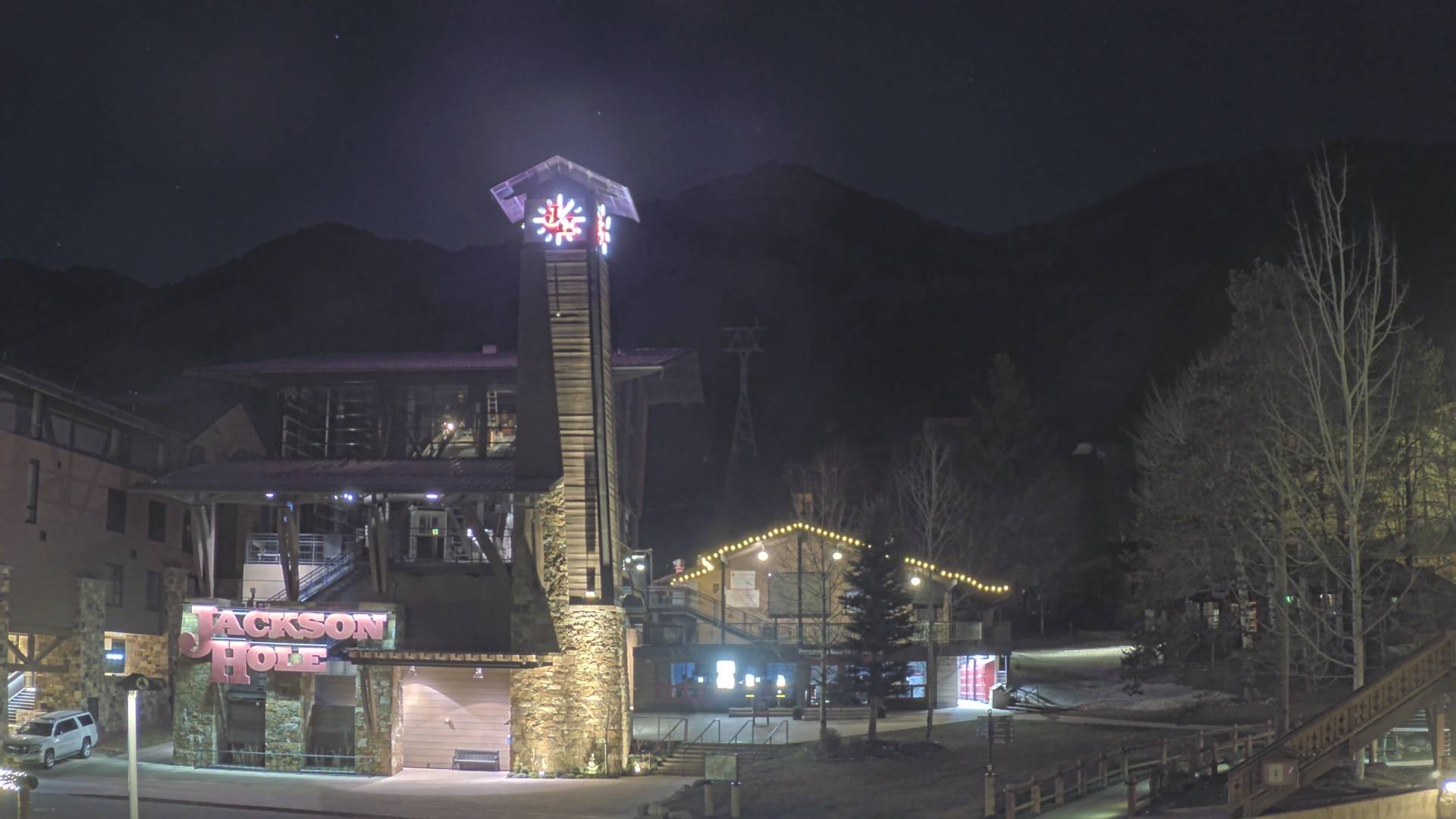
Tram Base
TUESDAY
Apr 7

32° / 17°

6 - 14
mph
 3
3
WEDNESDAY
Apr 8
30° / 21°
4 - 12
mph
0
THURSDAY
Apr 9

33° / 25°
5 - 13
mph
0
FRIDAY
Apr 10

34° / 29°
4 - 12
mph
1
SATURDAY
Apr 11
35° / 32°
4 - 12
mph
2
SUNDAY
Apr 12
34° / 23°
5 - 12
mph
0
Cloudy becoming mostly cloudy at times and then partly cloudy overnight. Periods of snow are expected in the morning through evening.
Moderate snow during the day and light in the evening. Snowfall is forecast to be 2 to 3 during the day, and a trace amount in the evening.
Potential Precip:
0.13 to 0.65
Hi: 36°Low: 14°
1,104 feet to 7236 feet
Winds W at 10 to 19 mph in the morning, becoming variable at 4 to 12 mph in the afternoon, and then variable at 3 to 11 mph overnight.
Cloudy becoming mostly cloudy at times and then partly cloudy overnight. Periods of snow are expected in the morning through evening.
Heavy snow during the day and light in the evening. Snowfall is forecast to be 6 to 9 during the day, and a trace amount in the evening.
Potential Precip:
0.13 to 0.65
Hi: 17°Low: 14°
1,104 feet to 7236 feet
Winds W at 35 to 46 mph in the morning, becoming W at 14 to 23 mph in the afternoon, and then W at 19 to 30 mph with gusts to 39 overnight.
Partly cloudy through the day becoming mostly clear overnight. Expect windy conditions at times.
No snow.
No precipitation expected.
Hi: 34°Low: 17°
2,060 feet to 6859 feet
Winds variable at 4 to 12 mph in the morning, becoming variable at 4 to 11 mph in the afternoon, and then variable at 3 to 10 mph overnight.
Partly cloudy through the day becoming mostly clear overnight. Expect windy conditions at times.
No snow.
No precipitation expected.
Hi: 21°Low: 19°
2,060 feet to 6859 feet
Winds W at 27 to 38 mph in the morning, becoming W at 28 to 39 mph in the afternoon through overnight.
Clear becoming cloudy at times continuing through overnight, with windy conditions at times.
No snow.
No precipitation expected.
Hi: 36°Low: 21°
3,054 feet to 7566 feet
Winds variable at 4 to 12 mph in the morning, becoming variable at 4 to 11 mph in the afternoon through overnight.
Clear becoming cloudy at times continuing through overnight, with windy conditions at times.
No snow.
No precipitation expected.
Hi: 22°Low: 20°
3,054 feet to 7566 feet
Winds W at 29 to 40 mph in the morning, becoming W at 32 to 43 mph in the afternoon, and then W at 29 to 40 mph overnight.
Mostly cloudy becoming cloudy in the afternoon continuing through overnight, with periods of rain and snow expected overnight.
Periods of light snow throughout the day and overnight. Snowfall is forecast to be 1 to 2 inches.
Potential Precip:
0.08 to 0.41
Hi: 39°Low: 30°
6,139 feet to 8526 feet
Winds variable at 4 to 11 mph through the day, becoming variable at 5 to 12 mph overnight.
Mostly cloudy becoming cloudy in the afternoon continuing through overnight, with periods of snow developing in the evening through overnight.
Periods of light snow throughout the day, moderate at times overnight. Snowfall is forecast to be 4 to 6 inches.
Potential Precip:
0.08 to 0.41
Hi: 24°Low: 19°
6,139 feet to 8526 feet
Winds W at 26 to 37 mph through the day, becoming W at 25 to 36 mph with gusts to 43 overnight.
Cloudy becoming mostly cloudy in the evening continuing through overnight, with periods of rain and snow expected overnight.
Periods of light snow throughout the day and overnight. Snowfall is forecast to be 1 to 2 inches.
Potential Precip:
0.15 to 0.73
Hi: 39°Low: 35°
7,350 feet to 8038 feet
Winds variable at 5 to 12 mph through the day, becoming variable at 4 to 11 mph overnight.
Cloudy becoming mostly cloudy in the evening continuing through overnight, with periods of snow expected at any time.
Periods of moderate to heavy snow throughout the day and overnight. Snowfall is forecast to be 5 to 8 inches.
Potential Precip:
0.15 to 0.73
Hi: 23°Low: 20°
7,350 feet to 8038 feet
Winds W at 21 to 32 mph through the day, becoming W at 10 to 19 mph overnight.
Mostly cloudy becoming partly cloudy at times and then mostly clear overnight. Periods of snow are expected in the morning.
Periods of light snow throughout the day. Snowfall is forecast to be a trace amount.
Potential Precip:
0 to 0.01
Hi: 38°Low: 20°
4,125 feet to 8356 feet
Winds variable at 4 to 11 mph through the day, becoming variable at 5 to 12 mph overnight.
Mostly cloudy becoming partly cloudy at times and then mostly clear overnight. Periods of snow are expected in the morning.
Periods of light snow throughout the day. Snowfall is forecast to be a trace amount.
Potential Precip:
0 to 0.01
Hi: 26°Low: 22°
4,125 feet to 8356 feet
Winds variable at 4 to 12 mph through the day, becoming variable at 5 to 13 mph overnight.
 Sunrise & Sunset

Lunar Calendar


 Snow Maps and Weather Stations in the Area
 ![]() 18in, past 4 days. Snow surface is powder and machine groomed
18in, past 4 days. Snow surface is powder and machine groomed
Snow report provided by SnoCountry
 Mountain Base


