 Stevens Pass... Summit @ Sno... Summit @ Sno... Summit @ Sno...
 Aspen Mountain – Ajax
  Aspen Mountain Updated Oct 02 @ 11:00

 South
South WebCams
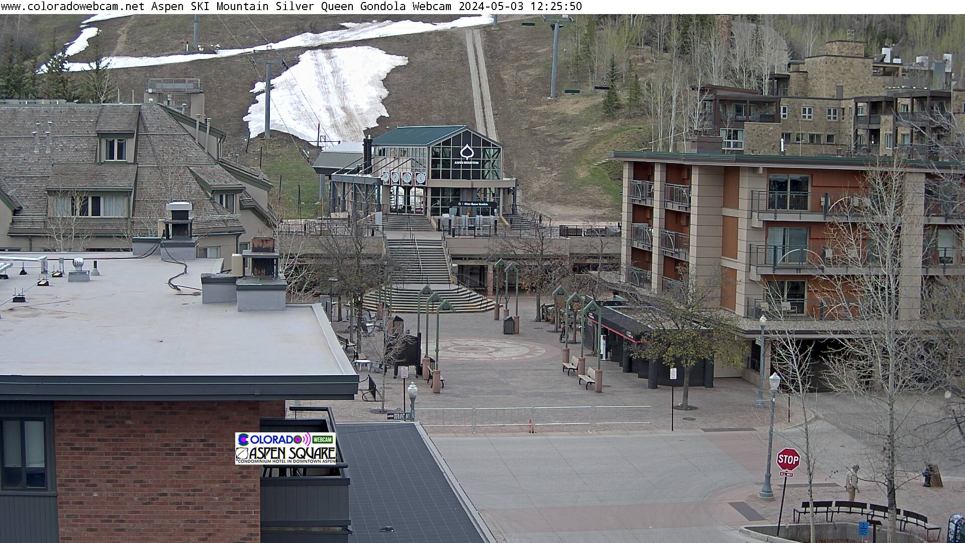
Aspen Gondola
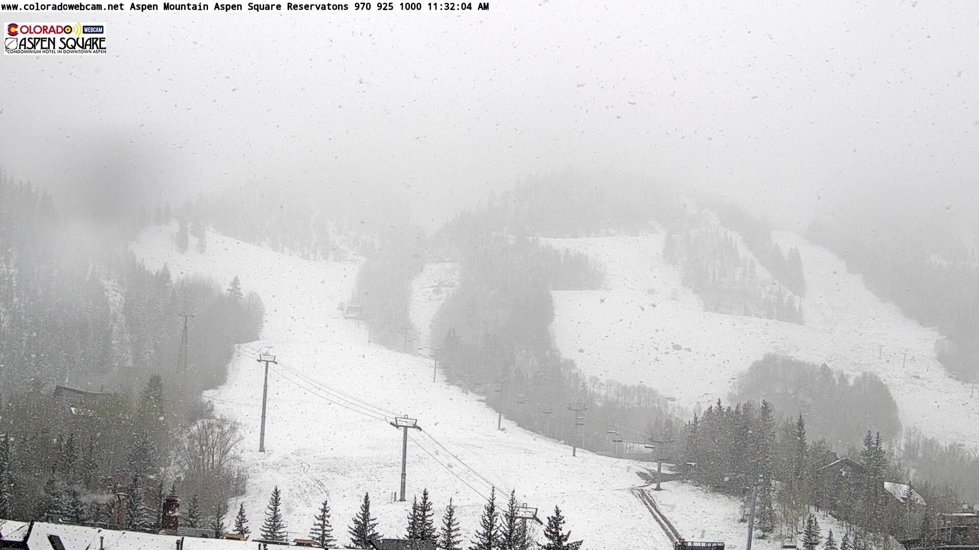
Aspen Mountain

Upper Gondola

Lower Gondola
SATURDAY
May 4

55° / 39°

6 - 14
mph
 0
0
SUNDAY
May 5

54° / 20°
8 - 16
mph
4
MONDAY
May 6
35° / 29°
5 - 12
mph
2
TUESDAY
May 7
37° / 15°
7 - 15
mph
0
WEDNESDAY
May 8

40° / 25°
5 - 13
mph
0
THURSDAY
May 9
43° / 28°
4 - 12
mph
1
FRIDAY
May 10
42° / 32°
5 - 13
mph
1
Mostly cloudy becoming partly cloudy at times continuing through overnight, with periods of rain expected in the morning.
No snow.
Potential Precip:
0.04 to 0.18
Hi: 55°Low: 40°
10,944 feet to 12873 feet
Winds SW at 8 to 16 mph in the morning, becoming SE at 6 to 14 mph in the afternoon, and then SE at 11 to 20 mph overnight.
Mostly cloudy becoming partly cloudy at times continuing through overnight, with periods of rain and snow expected overnight.
Periods of light snow during the day. Snowfall is forecast to be a trace amount during the day.
Potential Precip:
0.04 to 0.18
Hi: 41°Low: 32°
10,944 feet to 12873 feet
Winds SW at 10 to 19 mph in the morning, becoming SE at 10 to 19 mph in the afternoon, and then S at 17 to 28 mph with gusts to 39 overnight.
Mostly cloudy becoming cloudy in the late morning and then mostly cloudy overnight. Periods of rain and snow are expected overnight.
Moderate snow with periods of heavy through the evening and overnight. Snowfall is forecast to be 3 to 6 inches in the evening and overnight.
Potential Precip:
0.25 to 1.27
Hi: 54°Low: 21°
4,772 feet to 12733 feet
Winds SW at 13 to 22 mph in the morning, becoming S at 8 to 16 mph in the afternoon, and then SW at 9 to 17 mph overnight.
Mostly cloudy becoming cloudy in the late morning and then mostly cloudy overnight. Periods of rain and snow are expected overnight.
Light snow with periods of moderate during the day, becoming heavy in the evening and moderate with periods of heavy overnight. Snowfall is forecast to be 1 to 2 during the day, and 7 to 11 inches in the evening and overnight.
Potential Precip:
0.25 to 1.27
Hi: 41°Low: 11°
4,772 feet to 12733 feet
Winds SW at 18 to 29 mph in the morning, becoming S at 13 to 22 mph with gusts to 28 in the afternoon, and then SW at 13 to 22 mph with gusts to 37 overnight.
Mostly cloudy through the day and overnight. Periods of snow are expected in the afternoon through overnight.
Light snow through the day into the evening, becoming moderate overnight. Snowfall is forecast to be a trace amount during the day, and 2 to 3 inches in the evening and overnight.
Potential Precip:
0.14 to 0.69
Hi: 35°Low: 30°
7,277 feet to 8815 feet
Winds W at 11 to 20 mph in the morning, becoming variable at 5 to 12 mph in the afternoon, and then W at 9 to 17 mph with gusts to 24 overnight.
Mostly cloudy through the day and overnight. Periods of snow are expected in the afternoon through overnight.
Light snow with periods of moderate during the day, becoming moderate in the evening and heavy overnight. Snowfall is forecast to be 1 to 2 during the day, and 5 to 8 inches in the evening and overnight.
Potential Precip:
0.14 to 0.69
Hi: 22°Low: 19°
7,277 feet to 8815 feet
Winds W at 13 to 24 mph with gusts to 30 in the morning, becoming SW at 9 to 17 mph with gusts to 30 in the afternoon, and then W at 13 to 24 mph with gusts to 41 overnight.
Mostly cloudy becoming partly cloudy at times continuing through overnight, with periods of snow expected in the morning through evening.
Periods of light snow throughout the day. Snowfall is forecast to be a trace amount.
Potential Precip:
0.02 to 0.09
Hi: 37°Low: 16°
3,299 feet to 9430 feet
Winds W at 23 to 34 mph in the morning, becoming W at 7 to 15 mph in the afternoon, and then variable at 4 to 12 mph overnight.
Mostly cloudy becoming partly cloudy at times continuing through overnight, with periods of snow expected in the morning through evening.
Periods of light snow throughout the day. Snowfall is forecast to be 1 to 2 inches.
Potential Precip:
0.02 to 0.09
Hi: 24°Low: 9°
3,299 feet to 9430 feet
Winds W at 35 to 46 mph in the morning, becoming W at 14 to 23 mph with gusts to 29 in the afternoon, and then NW at 8 to 16 mph with gusts to 26 overnight.
Mostly cloudy becoming cloudy at times continuing through overnight, with periods of rain and snow expected overnight.
Periods of light snow throughout the day. Snowfall is forecast to be a trace amount.
Potential Precip:
0.01 to 0.06
Hi: 41°Low: 25°
5,990 feet to 10242 feet
Winds variable at 5 to 13 mph through the day, becoming variable at 4 to 11 mph overnight.
Mostly cloudy becoming cloudy at times continuing through overnight, with periods of snow expected in the morning through overnight.
Periods of light snow throughout the day and overnight. Snowfall is forecast to be 1 to 2 inches.
Potential Precip:
0.01 to 0.06
Hi: 27°Low: 19°
5,990 feet to 10242 feet
Winds variable at 7 to 15 mph through the day, becoming variable at 3 to 11 mph overnight.
Cloudy becoming partly cloudy at times and then mostly cloudy overnight. Periods of rain and snow are expected overnight.
Periods of light snow throughout the day and overnight. Snowfall is forecast to be 1 to 2 inches.
Potential Precip:
0.16 to 0.82
Hi: 44°Low: 29°
6,964 feet to 10815 feet
Winds variable at 4 to 12 mph through the day, becoming variable at 5 to 13 mph overnight.
Cloudy becoming partly cloudy at times and then mostly cloudy overnight. Periods of snow are expected at any time.
Periods of moderate to heavy snow throughout the day, moderate at times overnight. Snowfall is forecast to be 5 to 8 inches.
Potential Precip:
0.16 to 0.82
Hi: 30°Low: 22°
6,964 feet to 10815 feet
Winds variable at 4 to 12 mph through the day, becoming SE at 8 to 16 mph with gusts to 22 overnight.
Cloudy becoming partly cloudy at times continuing through overnight. Periods of rain and snow are expected overnight.
Periods of light to moderate snow throughout the day. Snowfall is forecast to be 1 to 2 inches.
Potential Precip:
0.15 to 0.76
Hi: 42°Low: 32°
7,975 feet to 10498 feet
Winds variable at 5 to 13 mph through the day, becoming variable at 5 to 12 mph overnight.
Cloudy becoming partly cloudy at times continuing through overnight. Periods of snow are expected in the morning through overnight.
Periods of moderate to heavy snow throughout the day, moderate at times overnight. Snowfall is forecast to be 4 to 7 inches.
Potential Precip:
0.15 to 0.76
Hi: 28°Low: 25°
7,975 feet to 10498 feet
Winds variable at 5 to 13 mph through the day, becoming variable at 4 to 12 mph overnight.
advertisement

 Sunrise & Sunset

Lunar Calendar


 Snow Maps and Weather Stations in the Area
 ![]() 15in, past 6 days. Snow surface is packed powder
15in, past 6 days. Snow surface is packed powder
Snow report provided by SnoCountry
Plan your future trip using our temperature, snowfall, snow depth, and precipitation tool
 Day |
 High Temperatures |
 Low Temperatures |
 Precipitation |
 Snowfall |
 Snow Depth |
||||||||||||||
|---|---|---|---|---|---|---|---|---|---|---|---|---|---|---|---|---|---|---|---|
| Avg | High | Year | Low | Year | Avg | High | Year | Low | Year | Avg | Max | Year | Avg | Max | Year | Avg | Max | Year | |
| 1 | 57 | 74 | 2002 | 33 | 2011 | 30 | 41 | 2007 | 19 | 2014 | 0.081 | 0.52 | 2013 | 0.57 | 7.0 | 2013 | 2.4 | 21 | 1984 |
| 2 | 55 | 74 | 1986 | 32 | 2013 | 31 | 44 | 1981 | 15 | 2013 | 0.081 | 0.92 | 1999 | 0.60 | 6.3 | 1999 | 2.6 | 22 | 1984 |
| 3 | 56 | 73 | 2000 | 39 | 2011 | 31 | 44 | 1986 | 18 | 2008 | 0.070 | 0.90 | 1981 | 0.19 | 2.0 | 1984 | 1.8 | 22 | 1984 |
| 4 | 59 | 74 | 2000 | 34 | 2001 | 32 | 40 | 2014 | 22 | 2008 | 0.121 | 1.30 | 2001 | 0.85 | 12.2 | 2001 | 2.1 | 20 | 1984 |
| 5 | 60 | 77 | 2000 | 37 | 1999 | 32 | 41 | 2000 | 21 | 1999 | 0.061 | 0.63 | 2001 | 0.36 | 4.5 | 2003 | 1.6 | 20 | 1984 |
| 6 | 60 | 76 | 2000 | 37 | 1999 | 32 | 42 | 2000 | 16 | 1999 | 0.106 | 1.00 | 1984 | 0.56 | 8.0 | 1984 | 1.5 | 26 | 1984 |
| 7 | 58 | 74 | 1989 | 40 | 1983 | 32 | 42 | 2000 | 21 | 2010 | 0.055 | 0.35 | 1986 | 0.19 | 3.0 | 1983 | 1.0 | 21 | 1984 |
| 8 | 59 | 76 | 1991 | 42 | 1986 | 31 | 42 | 1989 | 18 | 1993 | 0.097 | 0.62 | 2008 | 0.15 | 2.0 | 2005 | 0.9 | 20 | 1984 |
| 9 | 59 | 76 | 1989 | 38 | 2013 | 32 | 42 | 2004 | 17 | 2002 | 0.070 | 0.52 | 2000 | 0.26 | 5.7 | 1995 | 0.9 | 17 | 1984 |
| 10 | 60 | 74 | 1991 | 43 | 2015 | 33 | 44 | 1989 | 22 | 2003 | 0.103 | 0.87 | 2015 | 0.72 | 7.0 | 2015 | 1.1 | 15 | 1984 |
| 11 | 60 | 73 | 2004 | 38 | 1999 | 33 | 49 | 2004 | 18 | 1999 | 0.048 | 0.50 | 1999 | 0.26 | 3.0 | 1999 | 0.7 | 10 | 1984 |
| 12 | 61 | 76 | 2007 | 33 | 2011 | 31 | 43 | 2007 | 15 | 1983 | 0.093 | 0.85 | 2011 | 0.48 | 5.0 | 2011 | 0.8 | 6 | 2011 |
| 13 | 60 | 77 | 1996 | 31 | 2014 | 32 | 44 | 2007 | 16 | 1983 | 0.119 | 1.10 | 1982 | 0.77 | 8.5 | 1982 | 0.9 | 9 | 1982 |
| 14 | 60 | 78 | 1996 | 38 | 1985 | 34 | 44 | 2006 | 20 | 2014 | 0.041 | 0.30 | 1983 | 0.11 | 2.2 | 1983 | 0.0 | 0 | 2015 |
| 15 | 62 | 75 | 1996 | 44 | 1991 | 35 | 45 | 1996 | 26 | 1998 | 0.089 | 1.00 | 1983 | 0.34 | 9.0 | 1983 | 0.0 | 1 | 1986 |
| 16 | 62 | 78 | 1988 | 42 | 1991 | 36 | 46 | 2000 | 28 | 1982 | 0.040 | 0.22 | 1986 | 0.14 | 4.0 | 1990 | 0.0 | 1 | 1983 |
| 17 | 64 | 76 | 1996 | 35 | 1983 | 35 | 48 | 1988 | 25 | 1999 | 0.074 | 1.30 | 1983 | 0.51 | 13.0 | 1983 | 0.6 | 16 | 1983 |
| 18 | 64 | 76 | 1991 | 39 | 1983 | 36 | 44 | 2014 | 25 | 1983 | 0.054 | 0.48 | 1981 | 0.06 | 2.0 | 1983 | 0.3 | 10 | 1983 |
| 19 | 66 | 78 | 2009 | 45 | 1983 | 37 | 46 | 2009 | 25 | 1983 | 0.069 | 0.55 | 1988 | 0.05 | 1.8 | 2011 | 0.3 | 8 | 1983 |
| 20 | 64 | 79 | 2005 | 37 | 2011 | 37 | 44 | 2005 | 27 | 2011 | 0.060 | 0.25 | 2013 | 0.12 | 2.6 | 1983 | 0.2 | 4 | 1983 |
| 21 | 65 | 80 | 2005 | 45 | 2011 | 36 | 45 | 2008 | 20 | 2001 | 0.050 | 0.50 | 1992 | 0.10 | 2.0 | 1981 | 0.1 | 2 | 2011 |
| 22 | 66 | 78 | 2005 | 50 | 2013 | 37 | 47 | 2012 | 25 | 2001 | 0.045 | 0.41 | 1997 | 0.00 | 0.0 | 2015 | 0.0 | 0 | 2015 |
| 23 | 65 | 78 | 2005 | 46 | 2007 | 36 | 46 | 2005 | 27 | 2002 | 0.057 | 0.55 | 2006 | 0.09 | 3.0 | 2007 | 0.1 | 3 | 2007 |
| 24 | 66 | 78 | 2005 | 47 | 2007 | 37 | 48 | 1989 | 25 | 2002 | 0.045 | 0.55 | 2012 | 0.01 | 0.5 | 2012 | 0.0 | 0 | 2015 |
| 25 | 64 | 79 | 2003 | 47 | 2015 | 35 | 43 | 2006 | 23 | 2010 | 0.065 | 0.44 | 2015 | 0.00 | 0.0 | 2015 | 0.0 | 0 | 2015 |
| 26 | 65 | 77 | 2006 | 50 | 2015 | 37 | 47 | 2006 | 29 | 1997 | 0.060 | 0.62 | 1996 | 0.00 | 0.0 | 2015 | 0.0 | 0 | 2015 |
| 27 | 66 | 76 | 2006 | 45 | 1996 | 38 | 47 | 1981 | 26 | 1987 | 0.077 | 1.00 | 1992 | 0.04 | 1.4 | 1995 | 0.0 | 1 | 1995 |
| 28 | 67 | 83 | 2010 | 47 | 1995 | 38 | 47 | 2001 | 27 | 2012 | 0.042 | 0.65 | 1993 | T | T | 1995 | 0.0 | T | 1995 |
| 29 | 68 | 83 | 2003 | 50 | 1995 | 38 | 49 | 2000 | 21 | 2006 | 0.063 | 0.41 | 1997 | 0.00 | 0.0 | 2015 | 0.0 | 0 | 2015 |
| 30 | 67 | 84 | 2000 | 47 | 1995 | 38 | 49 | 2003 | 29 | 2010 | 0.072 | 0.40 | 2003 | 0.06 | 1.0 | 2004 | 0.0 | 1 | 1988 |
| 31 | 67 | 86 | 2003 | 44 | 1995 | 37 | 50 | 2002 | 26 | 2011 | 0.055 | 0.40 | 2003 | 0.06 | 2.0 | 1988 | 0.1 | 2 | 1988 |
Day |
High Temperatures |
Low Temperatures |
Precipitation |
Snowfall |
Snow Depth |
||||||||||||||
|---|---|---|---|---|---|---|---|---|---|---|---|---|---|---|---|---|---|---|---|
| Avg | High | Year | Low | Year | Avg | High | Year | Low | Year | Avg | Max | Year | Avg | Max | Year | Avg | Max | Year | |
| 1 | 41 | 58 | 1992 | 19 | 1967 | 17 | 33 | 1959 | -8 | 1993 | 0.066 | 0.50 | 2006 | 0.95 | 8.1 | 1973 | 42.2 | 77 | 2011 |
| 2 | 42 | 59 | 1981 | 22 | 2008 | 18 | 33 | 1965 | -5 | 1993 | 0.076 | 0.93 | 1999 | 1.13 | 12.5 | 1999 | 41.8 | 77 | 2011 |
| 3 | 43 | 57 | 1985 | 24 | 2008 | 19 | 31 | 1985 | -6 | 1993 | 0.057 | 0.55 | 1984 | 0.77 | 7.8 | 1984 | 40.7 | 77 | 2011 |
| 4 | 45 | 56 | 2012 | 26 | 2001 | 21 | 36 | 1956 | 5 | 1973 | 0.044 | 0.37 | 2009 | 0.58 | 5.0 | 2009 | 39.1 | 74 | 2011 |
| 5 | 46 | 60 | 2000 | 30 | 1978 | 22 | 34 | 2004 | 3 | 1953 | 0.081 | 0.72 | 1969 | 1.02 | 10.0 | 2001 | 38.7 | 73 | 2011 |
| 6 | 46 | 60 | 2000 | 32 | 1999 | 21 | 36 | 2004 | 0 | 1993 | 0.094 | 1.00 | 1984 | 1.16 | 10.0 | 1978 | 37.5 | 80 | 1984 |
| 7 | 45 | 58 | 1966 | 27 | 1975 | 22 | 35 | 1963 | 3 | 1993 | 0.076 | 0.95 | 1969 | 0.84 | 10.5 | 1978 | 36.6 | 81 | 1984 |
| 8 | 45 | 59 | 1989 | 29 | 1978 | 22 | 39 | 1963 | 6 | 1984 | 0.086 | 0.72 | 1995 | 1.06 | 10.5 | 1959 | 35.4 | 77 | 1984 |
| 9 | 45 | 59 | 2004 | 30 | 1988 | 22 | 34 | 1977 | 3 | 1990 | 0.117 | 0.83 | 1957 | 1.39 | 9.5 | 2013 | 34.4 | 73 | 1984 |
| 10 | 45 | 58 | 1977 | 28 | 1953 | 22 | 34 | 2004 | 9 | 2003 | 0.078 | 0.59 | 1955 | 1.06 | 7.0 | 2003 | 34.1 | 68 | 1984 |
| 11 | 46 | 57 | 1987 | 28 | 1999 | 23 | 36 | 1962 | 0 | 1953 | 0.033 | 0.27 | 1966 | 0.41 | 5.0 | 1985 | 32.1 | 65 | 1984 |
| 12 | 45 | 60 | 2007 | 28 | 1896 | 22 | 38 | 1962 | 6 | 1979 | 0.066 | 0.70 | 2014 | 0.80 | 10.0 | 2014 | 31.3 | 65 | 2011 |
| 13 | 44 | 58 | 2001 | 25 | 2000 | 22 | 40 | 1996 | 5 | 1953 | 0.063 | 0.91 | 1982 | 0.76 | 12.5 | 1982 | 30.5 | 64 | 2011 |
| 14 | 46 | 59 | 1996 | 27 | 1967 | 23 | 40 | 1996 | -10 | 1896 | 0.047 | 0.46 | 1987 | 0.37 | 5.0 | 1982 | 28.3 | 59 | 2011 |
| 15 | 47 | 58 | 1984 | 32 | 2014 | 24 | 37 | 1955 | 12 | 1998 | 0.063 | 0.58 | 1957 | 0.95 | 11.0 | 1957 | 27.5 | 63 | 1957 |
| 16 | 48 | 60 | 2012 | 30 | 1957 | 25 | 36 | 2002 | 14 | 1974 | 0.096 | 0.98 | 1991 | 0.92 | 10.5 | 1991 | 26.3 | 63 | 1957 |
| 17 | 49 | 59 | 1996 | 34 | 1990 | 25 | 35 | 1964 | 11 | 1995 | 0.050 | 0.60 | 1995 | 0.44 | 7.5 | 1983 | 24.9 | 60 | 1957 |
| 18 | 48 | 70 | 2012 | 29 | 2000 | 26 | 35 | 2004 | 12 | 1980 | 0.039 | 0.35 | 2000 | 0.42 | 4.0 | 2000 | 23.5 | 57 | 1957 |
| 19 | 49 | 64 | 2009 | 27 | 2000 | 28 | 41 | 1996 | 11 | 1960 | 0.058 | 0.92 | 2016 | 0.50 | 7.0 | 2016 | 22.3 | 56 | 1957 |
| 20 | 50 | 61 | 1992 | 33 | 2000 | 27 | 36 | 1970 | 11 | 1960 | 0.069 | 0.53 | 1988 | 0.72 | 11.0 | 2011 | 20.7 | 64 | 2011 |
| 21 | 50 | 65 | 2005 | 28 | 1988 | 27 | 44 | 2005 | 5 | 1977 | 0.046 | 0.60 | 1893 | 0.39 | 6.0 | 1893 | 18.7 | 63 | 2011 |
| 22 | 51 | 68 | 2005 | 33 | 1988 | 27 | 39 | 2005 | 7 | 1977 | 0.072 | 1.10 | 1992 | 0.43 | 5.0 | 1992 | 17.5 | 60 | 2011 |
| 23 | 50 | 64 | 2005 | 35 | 1988 | 26 | 38 | 2012 | 11 | 1987 | 0.065 | 0.51 | 1954 | 0.34 | 5.0 | 1895 | 15.8 | 56 | 2011 |
| 24 | 51 | 64 | 2005 | 35 | 2007 | 27 | 39 | 2000 | 11 | 1994 | 0.030 | 0.37 | 2012 | 0.26 | 4.0 | 2012 | 14.7 | 56 | 1957 |
| 25 | 50 | 61 | 2006 | 36 | 1987 | 26 | 40 | 1896 | 11 | 1980 | 0.070 | 0.90 | 1999 | 0.47 | 7.0 | 1999 | 13.4 | 57 | 1957 |
| 26 | 50 | 65 | 2006 | 36 | 1984 | 26 | 37 | 1953 | 14 | 2012 | 0.060 | 0.91 | 1950 | 0.46 | 8.3 | 1950 | 12.3 | 55 | 2011 |
| 27 | 50 | 64 | 2006 | 30 | 1973 | 27 | 41 | 1896 | 9 | 1978 | 0.097 | 2.00 | 1973 | 0.33 | 5.0 | 1955 | 11.5 | 54 | 1957 |
| 28 | 51 | 63 | 2010 | 30 | 1973 | 27 | 38 | 1966 | 7 | 1978 | 0.043 | 0.80 | 1894 | 0.08 | 2.0 | 1978 | 10.0 | 53 | 1957 |
| 29 | 52 | 66 | 2010 | 32 | 1975 | 28 | 40 | 2003 | 14 | 1973 | 0.064 | 1.50 | 1894 | 0.45 | 13.0 | 1975 | 9.2 | 51 | 1957 |
| 30 | 52 | 68 | 2000 | 37 | 1964 | 29 | 42 | 2000 | 15 | 2004 | 0.109 | 3.00 | 1895 | 0.67 | 30.0 | 1895 | 8.1 | 48 | 1957 |
| 31 | 51 | 71 | 2002 | 32 | 2004 | 28 | 44 | 2002 | 11 | 1975 | 0.064 | 1.20 | 1895 | 0.39 | 12.0 | 1895 | 6.4 | 48 | 1957 |
advertisement
advertisement

 Mountain Base


