 Stevens Pass... Summit @ Sno... Summit @ Sno... Summit @ Sno...
 Canyons Resort
  Heber Valley Airport, UT Updated May 05 @ 03:11

 South
South WebCams

ski beach
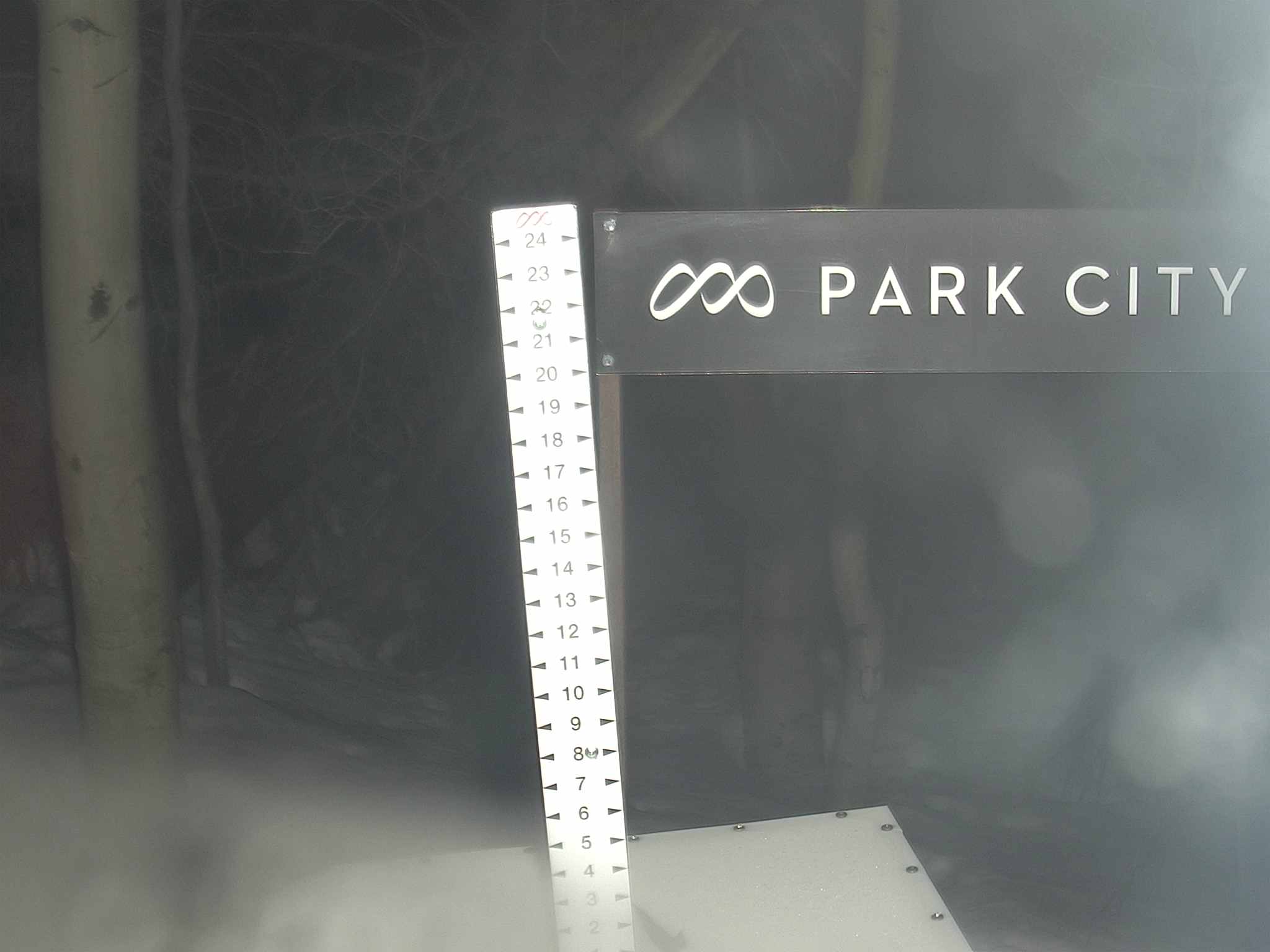
snow stake
SUNDAY
May 5

31° / 24°

6 - 14
mph
 10
10
MONDAY
May 6
35° / 28°
4 - 12
mph
9
TUESDAY
May 7

29° / 20°
5 - 13
mph
5
WEDNESDAY
May 8
35° / 30°
6 - 14
mph
0
THURSDAY
May 9
39° / 31°
6 - 14
mph
0
FRIDAY
May 10

45° / 36°
5 - 13
mph
0
advertisement

Mostly cloudy through the day and overnight, with periods of snow expected in the morning through overnight.
Heavy snow during the day, becoming light in the evening and moderate overnight. Snowfall is forecast to be 3 to 5 during the day, and 3 to 5 inches in the evening and overnight.
Potential Precip:
0.39 to 1.96
Hi: 35°Low: 26°
4,990 feet to 7480 feet
Winds variable at 5 to 13 mph through the day, becoming SW at 7 to 15 mph overnight.
Mostly cloudy through the day and overnight, with periods of snow expected in the morning through overnight.
Heavy snow during the day, becoming moderate in the evening and heavy overnight. Snowfall is forecast to be 9 to 13 during the day, and 6 to 9 inches in the evening and overnight.
Potential Precip:
0.39 to 1.96
Hi: 23°Low: 17°
4,990 feet to 7480 feet
Winds SW at 10 to 18 mph with gusts to 29 in the morning, becoming W at 11 to 20 mph in the afternoon, and then W at 14 to 25 mph with gusts to 35 overnight.
Partly cloudy becoming mostly cloudy at times continuing through overnight. Periods of snow are expected at any time.
Light snow during the day, becoming moderate in the evening through overnight with periods of heavy overnight. Snowfall is forecast to be a trace amount during the day, and 4 to 7 inches in the evening and overnight.
Potential Precip:
0.33 to 1.65
Hi: 39°Low: 30°
6,218 feet to 8230 feet
Winds W at 6 to 14 mph in the morning, becoming variable at 5 to 12 mph in the afternoon, and then W at 6 to 14 mph overnight.
Partly cloudy becoming mostly cloudy at times continuing through overnight. Periods of snow are expected at any time.
Moderate snow during the day, becoming heavy in the evening through overnight. Snowfall is forecast to be 2 to 3 during the day, and 12 to 16 inches in the evening and overnight.
Potential Precip:
0.33 to 1.65
Hi: 24°Low: 16°
6,218 feet to 8230 feet
Winds W at 13 to 24 mph in the morning, becoming W at 6 to 14 mph in the afternoon, and then W at 14 to 25 mph with gusts to 33 overnight.
Mostly cloudy becoming partly cloudy in the evening continuing through overnight, with periods of snow expected at any time.
Periods of moderate to heavy snow throughout the day, light at times overnight. Snowfall is forecast to be 3 to 6 inches.
Potential Precip:
0.13 to 0.67
Hi: 33°Low: 21°
3,355 feet to 6976 feet
Winds W at 8 to 16 mph in the morning, becoming variable at 4 to 12 mph in the afternoon, and then variable at 5 to 12 mph overnight.
Mostly cloudy becoming partly cloudy in the evening continuing through overnight, with periods of snow expected at any time.
Periods of heavy snow throughout the day, light at times overnight. Snowfall is forecast to be 6 to 9 inches.
Potential Precip:
0.13 to 0.67
Hi: 17°Low: 13°
3,355 feet to 6976 feet
Winds W at 19 to 30 mph in the morning, becoming NW at 14 to 25 mph with gusts to 33 in the afternoon, and then NW at 10 to 18 mph with gusts to 31 overnight.
Partly cloudy becoming mostly clear at times continuing through overnight, with periods of rain and snow expected overnight.
Periods of light snow throughout the day. Snowfall is forecast to be a trace amount.
Potential Precip:
0 to 0.02
Hi: 40°Low: 29°
5,902 feet to 8278 feet
Winds variable at 5 to 13 mph throughout the day and into overnight.
Partly cloudy becoming mostly clear at times continuing through overnight, with periods of snow expected in the morning through overnight.
Periods of light snow throughout the day and overnight. Snowfall is forecast to be a trace amount.
Potential Precip:
0 to 0.02
Hi: 25°Low: 21°
5,902 feet to 8278 feet
Winds variable at 10 to 18 mph through the day, becoming NE at 8 to 16 mph with gusts to 23 overnight.
Partly cloudy becoming mostly clear in the afternoon continuing through overnight.
Periods of light snow throughout the day. Snowfall is forecast to be a trace amount.
Potential Precip:
0.05 to 0.26
Hi: 44°Low: 30°
7,119 feet to 9462 feet
Winds variable at 5 to 13 mph through the day, becoming variable at 3 to 11 mph overnight.
Partly cloudy becoming mostly clear in the afternoon continuing through overnight, with periods of snow expected in the morning.
Periods of light to moderate snow throughout the day. Snowfall is forecast to be 1 to 2 inches.
Potential Precip:
0.05 to 0.26
Hi: 29°Low: 28°
7,119 feet to 9462 feet
Winds E at 7 to 15 mph through the day, becoming variable at 3 to 11 mph overnight.
Partly cloudy becoming clear in the late morning continuing through overnight.
No snow.
Potential Precip:
0.02 to 0.09
Hi: 50°Low: 36°
8,409 feet to 10085 feet
Winds variable at 5 to 13 mph through the day, becoming variable at 5 to 12 mph overnight.
Partly cloudy becoming clear in the late morning continuing through overnight.
Periods of snow throughout the day and overnight.
Potential Precip:
0.02 to 0.09
Hi: 33°Low: 29°
8,409 feet to 10085 feet
Winds variable at 4 to 12 mph through the day, becoming NW at 6 to 14 mph overnight.
 Sunrise & Sunset

Lunar Calendar


 Snow Maps and Weather Stations in the Area
 advertisement
 Mountain Base


